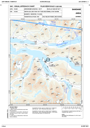
VAC chart of ENSD
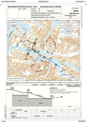
 IAC chart of ENSD
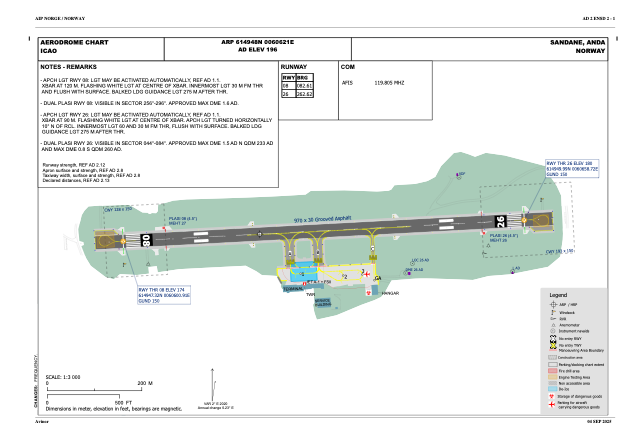
 ADC chart of ENSD
 Satellite view of ENSD

IAC chart of ENSDADC chart of ENSD
Satellite view of ENSD
Sorry, we have no imagery here.
Sorry, we have no imagery here.
Sorry, we have no imagery here.
Sorry, we have no imagery here.
Sorry, we have no imagery here.
Sorry, we have no imagery here.


ENSD - Anda
Located in Sandane, Norway
ICAO - ENSD, IATA - SDN
Data provided by AirmateGeneral information
Coordinates: N61°49'48" E6°6'21"
Elevation is 195 feet MSL.
Magnetic variation is 1.8° East View others Airports in Sogn og Fjordane
Operational data
Special qualification required
Current time UTC:
Current local time:
Weather
METAR: ENSD 091720Z VRB02KT 8000 -RADZ FEW003 SCT005 BKN018 05/04 Q1009 RMK WIND RWY 26 VRB03KT WIND 1140FT 32005KT
TAF: TAF ENSD 091400Z 0915/0922 VRB04KT 9999 -RA FEW005 BKN020 TEMPO 0915/0921 0200 RADZ FG VV002
Communications frequencies: [VIEW]
Runways:
| RWY identifier | QFU | Length (ft) | Width (ft) | Surface | LDA (ft) |
| 08 | 0° | 3182 | 98 | UNK | |
| 26 | 0° | 3182 | 98 | UNK |
Airport contact information
Address: Sandane Norway
Satellite view of ENSD
Sorry, we have no imagery here.
Sorry, we have no imagery here.
Sorry, we have no imagery here.
Sorry, we have no imagery here.
Sorry, we have no imagery here.
Sorry, we have no imagery here.