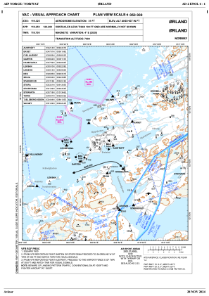
VAC chart of ENOL
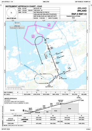
 IAC chart of ENOL
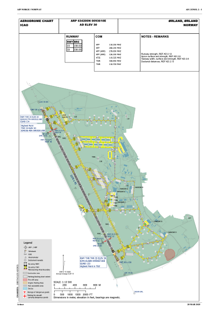
 ADC chart of ENOL
 Satellite view of ENOL
IAC chart of ENOLADC chart of ENOL
Satellite view of ENOL
Sorry, we have no imagery here.
Sorry, we have no imagery here.
Sorry, we have no imagery here.
Sorry, we have no imagery here.
Sorry, we have no imagery here.


ENOL - Oerland
Located in Oerland, Norway
ICAO - ENOL, IATA - OLA
Data provided by AirmateGeneral information
Coordinates: N63°42'0" E9°36'10"
Elevation is 30 feet MSL.
Magnetic variation is 3.5° East View others Airports in Sør-Trøndelag
Operational data
Special qualification required
Current time UTC:
Current local time:
Weather
TAF: TAF ENOL 131100Z 1312/1412 13015KT CAVOK TEMPO 1314/1320 06007KT TEMPO 1320/1403 4000 RADZ BKN007 BECMG 1322/1324 23015KT TEMPO 1401/1406 26025G35KT TEMPO 1406/1412 FEW030TCU
Communications frequencies: [VIEW]
Runways:
| RWY identifier | QFU | Length (ft) | Width (ft) | Surface | LDA (ft) |
| 15 | 154° | 10755 | 148 | ASP | |
| 33 | 334° | 10755 | 148 | ASP |
Airport contact information
Address: Oerland Norway
Other aviation service providers
Aviation club (not for profit)

Satellite view of ENOL
Sorry, we have no imagery here.
Sorry, we have no imagery here.
Sorry, we have no imagery here.
Sorry, we have no imagery here.
Sorry, we have no imagery here.