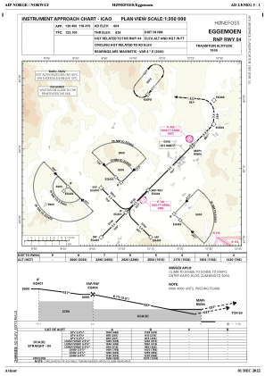
IAC chart of ENEG
 Satellite view of ENEG
Satellite view of ENEG
Sorry, we have no imagery here.
Sorry, we have no imagery here.
Sorry, we have no imagery here.
Sorry, we have no imagery here.
Sorry, we have no imagery here.
Sorry, we have no imagery here.


ENEG - Eggemoen
Located in Honefoss, Norway
ICAO - ENEG, IATA -
Data provided by AirmateGeneral information
Coordinates: N60°12'50" E10°19'2"
Elevation is 653 feet MSL.
Magnetic variation is 3.6° East View others Airports in Buskerud
Operational data
Special qualification required
Current time UTC:
Current local time:
Weather at : ENGM - Gardermoen ( 42 km )
METAR: ENGM 110650Z VRB02KT CAVOK 07/00 Q1006 NOSIG
TAF: TAF ENGM 110500Z 1106/1206 28007KT CAVOK
Communications frequencies: [VIEW]
Runways:
| RWY identifier | QFU | Length (ft) | Width (ft) | Surface | LDA (ft) |
| 04 | 0° | 5791 | 148 | Asphalt | |
| 22 | 0° | 5791 | 148 | Asphalt |
Airport contact information
Address: Honefoss Norway
Other aviation service providers
Aviation club (not for profit)

Satellite view of ENEG
Sorry, we have no imagery here.
Sorry, we have no imagery here.
Sorry, we have no imagery here.
Sorry, we have no imagery here.
Sorry, we have no imagery here.
Sorry, we have no imagery here.