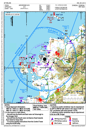
VAC chart of EIDL
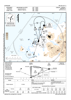
 IAC chart of EIDL
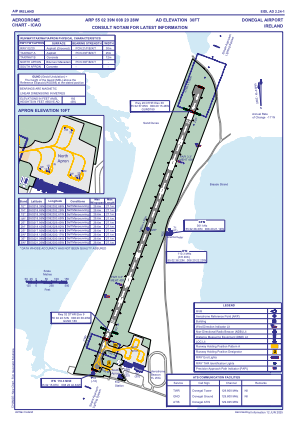
 ADC chart of EIDL
 Satellite view of EIDL
IAC chart of EIDLADC chart of EIDL
Satellite view of EIDL
Sorry, we have no imagery here.
Sorry, we have no imagery here.
Sorry, we have no imagery here.
Sorry, we have no imagery here.
Sorry, we have no imagery here.
Sorry, we have no imagery here.


EIDL - Donegal
Located in Donegal Town, Ireland
ICAO - EIDL, IATA - CFN
Data provided by AirmateGeneral information
Coordinates: N55°2'39" W8°20'28"
Elevation is 31 feet MSL.
Magnetic variation is -2.85° East View others Airports in County Donegal
Operational data
Special qualification required
Current time UTC:
Current local time:
Weather
TAF: TAF EIDL 091700Z 0918/1003 35008KT CAVOK
Communications frequencies: [VIEW]
Runways:
| RWY identifier | QFU | Length (ft) | Width (ft) | Surface | LDA (ft) |
| 03 | 20° | 4908 | 98 | ASPH | 3799 |
| 21 | 200° | 4908 | 98 | ASPH | 3950 |
Airport contact information
Address: Donegal Town Ireland
Satellite view of EIDL
Sorry, we have no imagery here.
Sorry, we have no imagery here.
Sorry, we have no imagery here.
Sorry, we have no imagery here.
Sorry, we have no imagery here.
Sorry, we have no imagery here.