IAC chart of EHGR
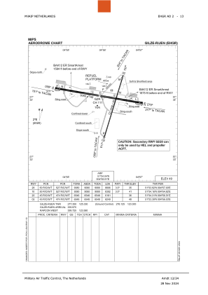
 ADC chart of EHGR
 Satellite view of EHGR
ADC chart of EHGR
Satellite view of EHGR
Sorry, we have no imagery here.
Sorry, we have no imagery here.
Sorry, we have no imagery here.
Sorry, we have no imagery here.
Sorry, we have no imagery here.
Sorry, we have no imagery here.


EHGR - Breda/Gilze-Rijen
Located in Breda, Netherlands
ICAO - EHGR, IATA - GLZ
Data provided by AirmateGeneral information
Coordinates: N51°34'3" E4°55'55"
Elevation is 49 feet MSL.
Magnetic variation is +1.683° East View others Airports in Noord-Brabant
Operational data
Special qualification required
Current time UTC:
Current local time:
Weather
METAR: EHGR 071825Z AUTO 03005KT 360V080 9999 NCD 09/M03 Q1025 BLU NOSIG
TAF: TAF EHGR 071630Z 0717/0805 04008KT CAVOK
Communications frequencies: [VIEW]
Runways:
| RWY identifier | QFU | Length (ft) | Width (ft) | Surface | LDA (ft) |
| 10 | 100° | 9080 | 148 | CONC+ASPH | 8672 |
| 28 | 280° | 9080 | 148 | CONC+ASPH | 8806 |
| 02 | 18° | 6548 | 98 | CONC+ASPH | 6249 |
| 20 | 198° | 6548 | 98 | CONC+ASPH | 6181 |
Airport contact information
Address: Breda Netherlands
Other aviation service providers
Flight schools

Helios Aero Services B.V.
Helios Aero Services B.V.
info@heliosaeroservices.com+31857441138
+31653518185
+31653518185
Koninklijke Luchtmacht Historische Vlucht
Koninklijke Luchtmacht Historische Vlucht
office@skhv.nl+31161222188
Satellite view of EHGR
Sorry, we have no imagery here.
Sorry, we have no imagery here.
Sorry, we have no imagery here.
Sorry, we have no imagery here.
Sorry, we have no imagery here.
Sorry, we have no imagery here.