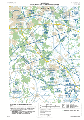
VAC chart of EHBD
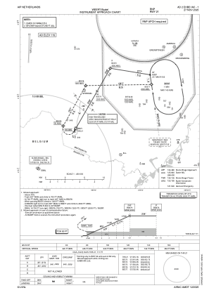
 IAC chart of EHBD
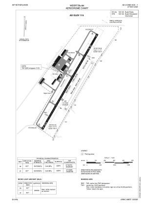
 ADC chart of EHBD
 Satellite view of EHBD
IAC chart of EHBDADC chart of EHBD
Satellite view of EHBD
Sorry, we have no imagery here.
Sorry, we have no imagery here.
Sorry, we have no imagery here.
Sorry, we have no imagery here.
Sorry, we have no imagery here.
Sorry, we have no imagery here.


EHBD - Weert/Budel
Located in Weert, Netherlands
ICAO - EHBD, IATA -
Data provided by AirmateGeneral information
Coordinates: N51°15'16" E5°36'3"
Elevation is 115 feet MSL.
Magnetic variation is 1.8093° East View others Airports in Noord-Brabant
Operational data
Special qualification required
Current time UTC:
Current local time:
Weather at : EBBL - Kleine-Brogel ( 13 km )
METAR: EBBL 081155Z 05007KT 9999 FEW280 15/M03 Q1026 BLU BLU
TAF: TAF EBBL 081141Z 0813/0822 08005KT 9999 FEW280 BECMG 0817/0819 05005KT SCT220
Communications frequencies: [VIEW]
Runways:
| RWY identifier | QFU | Length (ft) | Width (ft) | Surface | LDA (ft) |
| 03G | 30° | 1969 | 98 | GRASS | |
| 21G | 210° | 1969 | 98 | GRASS | |
| 03 | 30° | 3934 | 75 | ASPH | |
| 21 | 210° | 3934 | 75 | ASPH |
Airport contact information
Address: Weert Netherlands
Handlers

Other aviation service providers
Flight schools

Satellite view of EHBD
Sorry, we have no imagery here.
Sorry, we have no imagery here.
Sorry, we have no imagery here.
Sorry, we have no imagery here.
Sorry, we have no imagery here.
Sorry, we have no imagery here.