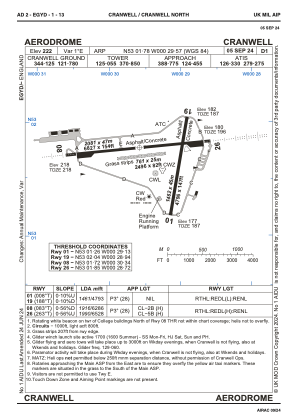
ADC chart of EGYD
 Satellite view of EGYD
Satellite view of EGYD
Sorry, we have no imagery here.
Sorry, we have no imagery here.
Sorry, we have no imagery here.
Sorry, we have no imagery here.
Sorry, we have no imagery here.
Sorry, we have no imagery here.


EGYD - Cranwell
Located in Sleaford, United Kingdom
ICAO - EGYD, IATA -
Data provided by AirmateGeneral information
Coordinates: N53°1'47" W0°29'34"
Elevation is 222 feet MSL.
Magnetic variation is 0° East View others Airports in England
Operational data
Special qualification required
Current time UTC:
Current local time:
Weather
METAR: EGYD 011050Z 09013KT CAVOK 11/04 Q1028 NOSIG RMK BLU BLU
TAF: TAF EGYD 011037Z 0112/0119 10012KT CAVOK
Communications frequencies: [VIEW]
Runways:
| RWY identifier | QFU | Length (ft) | Width (ft) | Surface | LDA (ft) |
| 01 | 8° | 4797 | 148 | ASPH | 4797 |
| 19 | 188° | 4797 | 148 | ASPH | 4797 |
| 08 | 83° | 6831 | 148 | ASPH | 6286 |
| 26 | 263° | 6831 | 148 | ASPH | 6532 |
| 08R | 0° | 0 | 0 | UNK | |
| 26L | 0° | 0 | 0 | UNK | |
| 08N | 83° | 2497 | 82 | GRAS | 2497 |
| 26N | 263° | 2497 | 82 | GRAS | 2497 |
| 03 | 0° | 3622 | 98 | UNK | |
| 06 | 0° | 3930 | 98 | UNK | |
| 21 | 0° | 3622 | 98 | UNK | |
| 24 | 0° | 3930 | 98 | UNK |
Airport contact information
Address: Sleaford United Kingdom
Satellite view of EGYD
Sorry, we have no imagery here.
Sorry, we have no imagery here.
Sorry, we have no imagery here.
Sorry, we have no imagery here.
Sorry, we have no imagery here.
Sorry, we have no imagery here.