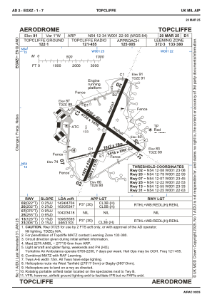
ADC chart of EGXZ
 Satellite view of EGXZ
Satellite view of EGXZ
Sorry, we have no imagery here.
Sorry, we have no imagery here.
Sorry, we have no imagery here.
Sorry, we have no imagery here.
Sorry, we have no imagery here.
Sorry, we have no imagery here.


EGXZ - Topcliffe
Located in Thirsk, United Kingdom
ICAO - EGXZ, IATA -
Data provided by AirmateGeneral information
Coordinates: N54°12'20" W1°22'54"
Elevation is 91 feet MSL.
Magnetic variation is -1° East View others Airports in England
Operational data
Special qualification required
Current time UTC:
Current local time:
Weather
METAR: EGXZ 010150Z AUTO 11006KT 9999 NCD 03/01 Q1029
Communications frequencies: [VIEW]
Runways:
| RWY identifier | QFU | Length (ft) | Width (ft) | Surface | LDA (ft) |
| 02 | 22° | 5991 | 148 | ASPH | 4705 |
| 20 | 202° | 5991 | 148 | ASPH | 5348 |
| 13 | 126° | 4121 | 148 | CONC | 3596 |
| 31 | 306° | 4121 | 148 | CONC | 3104 |
| 07 | 75° | 3418 | 59 | UNK | |
| 25 | 255° | 3418 | 59 | UNK |
Airport contact information
Address: Thirsk United Kingdom
Satellite view of EGXZ
Sorry, we have no imagery here.
Sorry, we have no imagery here.
Sorry, we have no imagery here.
Sorry, we have no imagery here.
Sorry, we have no imagery here.
Sorry, we have no imagery here.