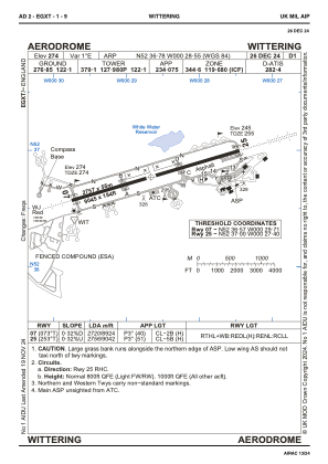
ADC chart of EGXT
 Satellite view of EGXT
Satellite view of EGXT
Sorry, we have no imagery here.
Sorry, we have no imagery here.
Sorry, we have no imagery here.
Sorry, we have no imagery here.
Sorry, we have no imagery here.
Sorry, we have no imagery here.


EGXT - Wittering
Located in Peterborough, United Kingdom
ICAO - EGXT, IATA -
Data provided by AirmateGeneral information
Coordinates: N52°36'47" W0°28'33"
Elevation is 274 feet MSL.
Magnetic variation is 0° East View others Airports in England
Operational data
Special qualification required
Current time UTC:
Current local time:
Weather
METAR: EGXT 010350Z AUTO 12006KT 9999 BR OVC002/// 03/02 Q1028
Communications frequencies: [VIEW]
Runways:
| RWY identifier | QFU | Length (ft) | Width (ft) | Surface | LDA (ft) |
| 07 | 73° | 9052 | 184 | ASPH | 8930 |
| 25 | 253° | 9052 | 184 | ASPH | 9045 |
Airport contact information
Address: Peterborough United Kingdom
Satellite view of EGXT
Sorry, we have no imagery here.
Sorry, we have no imagery here.
Sorry, we have no imagery here.
Sorry, we have no imagery here.
Sorry, we have no imagery here.
Sorry, we have no imagery here.