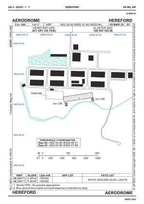
ADC chart of EGVH
 Satellite view of EGVH
Satellite view of EGVH
Sorry, we have no imagery here.
Sorry, we have no imagery here.
Sorry, we have no imagery here.
Sorry, we have no imagery here.
Sorry, we have no imagery here.
Sorry, we have no imagery here.


EGVH - Hereford
Located in Hereford, United Kingdom
ICAO - , IATA -
Data provided by AirmateGeneral information
Coordinates: N52°4'51" W2°47'56"
Elevation is 240 feet MSL.
Magnetic variation is -1° East View others Airports in England
Operational data
Special qualification required
Current time UTC:
Current local time:
Weather at : EGBJ - Gloucestershire ( 48 km )
TAF: TAF EGBJ 311404Z 3115/3119 12003KT 9999 FEW045
Communications frequencies: [VIEW]
Runways:
| RWY identifier | QFU | Length (ft) | Width (ft) | Surface | LDA (ft) |
| 08 | 0° | 492 | 68 | UNK | |
| 26 | 0° | 492 | 68 | UNK |
Airport contact information
Address: Hereford United Kingdom
Satellite view of EGVH
Sorry, we have no imagery here.
Sorry, we have no imagery here.
Sorry, we have no imagery here.
Sorry, we have no imagery here.
Sorry, we have no imagery here.
Sorry, we have no imagery here.