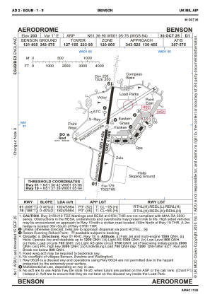
ADC chart of EGUB
 Satellite view of EGUB
Satellite view of EGUB
Sorry, we have no imagery here.
Sorry, we have no imagery here.
Sorry, we have no imagery here.
Sorry, we have no imagery here.
Sorry, we have no imagery here.
Sorry, we have no imagery here.


EGUB - Benson
Located in Wallingford, United Kingdom
ICAO - EGUB, IATA - BEX
Data provided by AirmateGeneral information
Coordinates: N51°36'54" W1°5'45"
Elevation is 203 feet MSL.
Magnetic variation is 0° East View others Airports in England
Operational data
Special qualification required
Current time UTC:
Current local time:
Weather
METAR: EGUB 010820Z 09009KT 9999 FEW015 09/06 Q1026 NOSIG RMK BLU BLU
TAF: TAF EGUB 010745Z 0109/0118 10012KT 9999 FEW015
Communications frequencies: [VIEW]
Runways:
| RWY identifier | QFU | Length (ft) | Width (ft) | Surface | LDA (ft) |
| 01 | 8° | 5988 | 148 | ASPH | 5988 |
| 19 | 188° | 5988 | 148 | ASPH | 5984 |
Airport contact information
Address: Wallingford United Kingdom
Other aviation service providers
Flight schools

Satellite view of EGUB
Sorry, we have no imagery here.
Sorry, we have no imagery here.
Sorry, we have no imagery here.
Sorry, we have no imagery here.
Sorry, we have no imagery here.
Sorry, we have no imagery here.