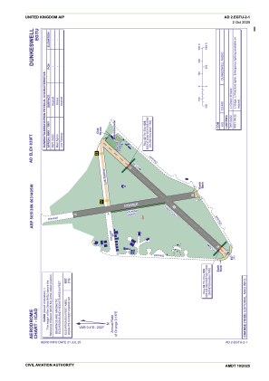
ADC chart of EGTU
 Satellite view of EGTU
Satellite view of EGTU
Sorry, we have no imagery here.
Sorry, we have no imagery here.
Sorry, we have no imagery here.
Sorry, we have no imagery here.
Sorry, we have no imagery here.
Sorry, we have no imagery here.


EGTU - Dunkeswell
Located in Exeter, United Kingdom
ICAO - EGTU, IATA -
Data provided by AirmateGeneral information
Coordinates: N50°51'36" W3°14'5"
Elevation is 839 feet MSL.
View others Airports in England
Operational data
Special qualification required
Current time UTC:
Current local time:
Weather at : EGTE - Exeter ( 19 km )
METAR: EGTE 011050Z 11020KT CAVOK 13/04 Q1023
TAF: TAF EGTE 011054Z 0112/0121 10014KT 9999 FEW025 TEMPO 0112/0121 12018G28KT
Communications frequencies: [VIEW]
Runways:
| RWY identifier | QFU | Length (ft) | Width (ft) | Surface | LDA (ft) |
| 04 | 41° | 3173 | 148 | ASP | |
| 22 | 221° | 3173 | 148 | ASP | |
| 17 | 170° | 3159 | 151 | ASP | |
| 35 | 350° | 3159 | 151 | ASP |
Airport contact information
Address: Exeter United Kingdom
Other aviation service providers
Flight schools

A.H. Helicopter Services Limited
A.H. Helicopter Services Limited
info@ahhelicopters.co.uk+44 07775533504
Devon & Somerset Flight Training Limited
Devon & Somerset Flight Training Limited
info@dsft.co.uk+44 01404891643
Satellite view of EGTU
Sorry, we have no imagery here.
Sorry, we have no imagery here.
Sorry, we have no imagery here.
Sorry, we have no imagery here.
Sorry, we have no imagery here.
Sorry, we have no imagery here.