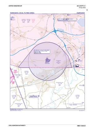
IAC chart of EGTF
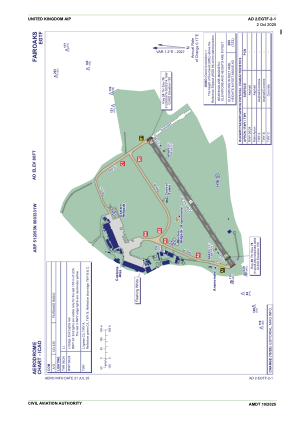
 ADC chart of EGTF
 Satellite view of EGTF
ADC chart of EGTF
Satellite view of EGTF
Sorry, we have no imagery here.
Sorry, we have no imagery here.
Sorry, we have no imagery here.
Sorry, we have no imagery here.
Sorry, we have no imagery here.
Sorry, we have no imagery here.


EGTF - Fairoaks
Located in Woking, United Kingdom
ICAO - EGTF, IATA -
Data provided by AirmateGeneral information
Coordinates: N51°20'53" W0°33'31"
Elevation is 80 feet MSL.
View others Airports in England
Operational data
Special qualification required
Current time UTC:
Current local time:
Weather at : EGLL - London Heathrow ( 16 km )
METAR: EGLL 010450Z AUTO 09008KT 9999 OVC010 06/04 Q1027
TAF: TAF EGLL 010454Z 0106/0212 09008KT 9999 FEW010 TEMPO 0106/0109 8000 BKN010 PROB30 TEMPO 0115/0118 08015G25KT
Communications frequencies: [VIEW]
Runways:
| RWY identifier | QFU | Length (ft) | Width (ft) | Surface | LDA (ft) |
| 06 | 58° | 2657 | 89 | asphalt | |
| 24 | 238° | 2657 | 89 | asphalt |
Airport contact information
Address: Woking United Kingdom
Other aviation service providers
Flight schools

London Transport Flying Club Limited
London Transport Flying Club Limited
info@ltfc.org.uk+44 01276858502
Synergy Aviation Limited T/A Fairoaks Flight Centre
Synergy Aviation Limited T/A Fairoaks Flight Centre
info@flysynergy.com+44 08456757757
Satellite view of EGTF
Sorry, we have no imagery here.
Sorry, we have no imagery here.
Sorry, we have no imagery here.
Sorry, we have no imagery here.
Sorry, we have no imagery here.
Sorry, we have no imagery here.