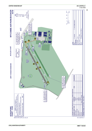
ADC chart of EGTB
 Satellite view of EGTB
Satellite view of EGTB
Sorry, we have no imagery here.
Sorry, we have no imagery here.
Sorry, we have no imagery here.
Sorry, we have no imagery here.
Sorry, we have no imagery here.
Sorry, we have no imagery here.


EGTB - Wycombe Air Park/Booker
Located in High Wycombe, United Kingdom
ICAO - EGTB, IATA - HYC
Data provided by AirmateGeneral information
Coordinates: N51°36'42" W0°48'30"
Elevation is 516 feet MSL.
View others Airports in England
Operational data
Special qualification required
Current time UTC:
Current local time:
Weather at : EGUB - Benson ( 20 km )
METAR: EGUB 011450Z 09014KT CAVOK 15/01 Q1023 NOSIG RMK BLU BLU
Communications frequencies: [VIEW]
Runways:
| RWY identifier | QFU | Length (ft) | Width (ft) | Surface | LDA (ft) |
| 06 | 62° | 2395 | 75 | Asphalt | |
| 24 | 242° | 2395 | 75 | Asphalt | |
| 06G | 62° | 2001 | 75 | Grass | |
| 24G | 242° | 2001 | 75 | Grass |
Airport contact information
Address: High Wycombe United Kingdom
Satellite view of EGTB
Sorry, we have no imagery here.
Sorry, we have no imagery here.
Sorry, we have no imagery here.
Sorry, we have no imagery here.
Sorry, we have no imagery here.
Sorry, we have no imagery here.