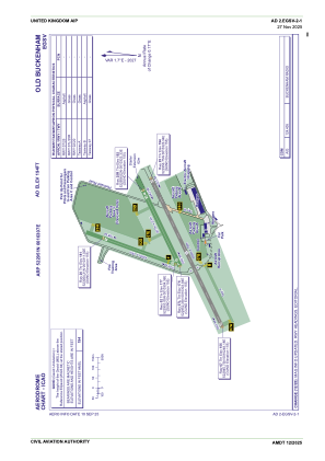
ADC chart of EGSV
 Satellite view of EGSV
Satellite view of EGSV
Sorry, we have no imagery here.
Sorry, we have no imagery here.
Sorry, we have no imagery here.
Sorry, we have no imagery here.
Sorry, we have no imagery here.
Sorry, we have no imagery here.


EGSV - Old Buckenham
Located in Norwich City, United Kingdom
ICAO - EGSV, IATA -
Data provided by AirmateGeneral information
Coordinates: N52°29'51" E1°3'7"
Elevation is 194 feet MSL.
View others Airports in England
Operational data
Special qualification required
Current time UTC:
Current local time:
Weather at : EGSH - Norwich ( 25 km )
METAR: EGSH 011150Z 11012KT 090V150 9999 FEW020 12/03 Q1029 NOSIG
TAF: TAF EGSH 011059Z 0112/0121 11010KT 9999 FEW020 BECMG 0118/0121 05007KT
Communications frequencies: [VIEW]
Runways:
| RWY identifier | QFU | Length (ft) | Width (ft) | Surface | LDA (ft) |
| 02 | 20° | 1404 | 59 | Grass | |
| 20 | 200° | 1404 | 59 | Grass | |
| 07L | 65° | 1548 | 75 | Grass | |
| 25R | 245° | 1548 | 75 | Grass | |
| 07 | 65° | 2618 | 59 | Asphalt | |
| 25 | 245° | 2618 | 59 | Asphalt |
Airport contact information
Address: Norwich City United Kingdom
Other aviation service providers
Flight schools

Old Buckenham Aero Club Limited
Old Buckenham Aero Club Limited
flyingoldbuck@gmail.com+44 01953861337
Satellite view of EGSV
Sorry, we have no imagery here.
Sorry, we have no imagery here.
Sorry, we have no imagery here.
Sorry, we have no imagery here.
Sorry, we have no imagery here.
Sorry, we have no imagery here.