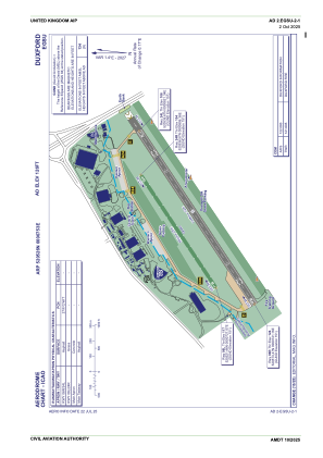
ADC chart of EGSU
 Satellite view of EGSU

Satellite view of EGSU
Sorry, we have no imagery here.
Sorry, we have no imagery here.
Sorry, we have no imagery here.
Sorry, we have no imagery here.
Sorry, we have no imagery here.
Sorry, we have no imagery here.


EGSU - Duxford
Located in Cambridge, United Kingdom
ICAO - EGSU, IATA - QFO
Data provided by AirmateGeneral information
Coordinates: N52°5'26" E0°7'53"
Elevation is 126 feet MSL.
View others Airports in England
Operational data
Special qualification required
Current time UTC:
Current local time:
Weather at : EGSC - Cambridge ( 13 km )
METAR: EGSC 011420Z 13009KT 080V150 CAVOK 14/01 Q1026
TAF: TAF EGSC 011357Z 0115/0117 10008KT CAVOK PROB30 TEMPO 0115/0117 10015G25KT
Communications frequencies: [VIEW]
Runways:
| RWY identifier | QFU | Length (ft) | Width (ft) | Surface | LDA (ft) |
| 06L | 58° | 2894 | 82 | GRS | |
| 24R | 238° | 2894 | 82 | GRS | |
| 06R | 58° | 4751 | 105 | UNK | |
| 24L | 238° | 4751 | 105 | UNK |
Airport contact information
Address: Cambridge United Kingdom
Satellite view of EGSU
Sorry, we have no imagery here.
Sorry, we have no imagery here.
Sorry, we have no imagery here.
Sorry, we have no imagery here.
Sorry, we have no imagery here.
Sorry, we have no imagery here.