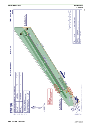
ADC chart of EGSR
 Satellite view of EGSR
Satellite view of EGSR
Sorry, we have no imagery here.
Sorry, we have no imagery here.
Sorry, we have no imagery here.
Sorry, we have no imagery here.
Sorry, we have no imagery here.


EGSR - Earls Colne
Located in Halstead, United Kingdom
ICAO - EGSR, IATA -
Data provided by AirmateGeneral information
Coordinates: N51°54'52" E0°40'57"
Elevation is 227 feet MSL.
View others Airports in England
Operational data
Special qualification required
Current time UTC:
Current local time:
Weather at : EGUW - Wattisham ( 30 km )
METAR: EGUW 010950Z 11010KT 9999 FEW030 10/03 Q1028 NOSIG RMK BLU BLU
TAF: TAF EGUW 010740Z 0109/0118 07010KT CAVOK
Communications frequencies: [VIEW]
Runways:
| RWY identifier | QFU | Length (ft) | Width (ft) | Surface | LDA (ft) |
| 06 | 60° | 3081 | 98 | UNK | |
| 24 | 240° | 3081 | 98 | UNK |
Airport contact information
Address: Halstead United Kingdom
Other aviation service providers
Flight schools

Steve Wilkes T/A Sws Steve Wilkes Seminars
Steve Wilkes T/A Sws Steve Wilkes Seminars
info@pilotgroundschool.co.uk+44 01787269820

Satellite view of EGSR
Sorry, we have no imagery here.
Sorry, we have no imagery here.
Sorry, we have no imagery here.
Sorry, we have no imagery here.
Sorry, we have no imagery here.