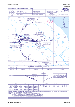
IAC chart of EGSH
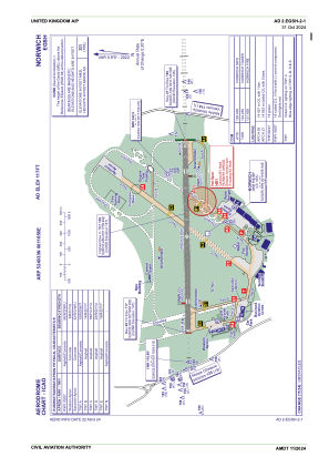
 ADC chart of EGSH
 Satellite view of EGSH
ADC chart of EGSH
Satellite view of EGSH
Sorry, we have no imagery here.
Sorry, we have no imagery here.
Sorry, we have no imagery here.
Sorry, we have no imagery here.
Sorry, we have no imagery here.
Sorry, we have no imagery here.


EGSH - Norwich
Located in Norwich, United Kingdom
ICAO - EGSH, IATA - NWI
Data provided by AirmateGeneral information
Coordinates: N52°40'33" E1°16'58"
Elevation is 117 feet MSL.
View others Airports in England
Operational data
Special qualification required
Current time UTC:
Current local time:
Weather
METAR: EGSH 010720Z 07005KT 8000 SCT007 06/05 Q1029 NOSIG
TAF: TAF EGSH 010459Z 0106/0115 VRB02KT 0300 FG OVC001 PROB30 TEMPO 0106/0108 9999 NSW FEW020 BECMG 0108/0111 CAVOK BECMG 0109/0112 11010KT
Communications frequencies: [VIEW]
Runways:
| RWY identifier | QFU | Length (ft) | Width (ft) | Surface | LDA (ft) |
| 09 | 89° | 6043 | 148 | ASP | |
| 27 | 269° | 6043 | 148 | ASP |
Airport contact information
Address: Norwich United Kingdom

Satellite view of EGSH
Sorry, we have no imagery here.
Sorry, we have no imagery here.
Sorry, we have no imagery here.
Sorry, we have no imagery here.
Sorry, we have no imagery here.
Sorry, we have no imagery here.