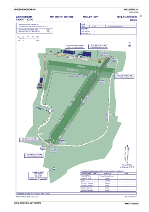
ADC chart of EGSG
 Satellite view of EGSG
Satellite view of EGSG
Sorry, we have no imagery here.
Sorry, we have no imagery here.
Sorry, we have no imagery here.
Sorry, we have no imagery here.
Sorry, we have no imagery here.
Sorry, we have no imagery here.


EGSG - Stapleford
Located in Romford, United Kingdom
ICAO - EGSG, IATA -
Data provided by AirmateGeneral information
Coordinates: N51°39'9" E0°9'22"
Elevation is 185 feet MSL.
View others Airports in England
Operational data
Special qualification required
Current time UTC:
Current local time:
Communications frequencies: [VIEW]
Runways:
| RWY identifier | QFU | Length (ft) | Width (ft) | Surface | LDA (ft) |
| 03R | 36° | 3533 | 151 | UNK | |
| 21L | 216° | 3533 | 151 | UNK | |
| 03L | 35° | 2953 | 98 | UNK | |
| 21R | 216° | 2953 | 98 | UNK |
Airport contact information
Address: Romford United Kingdom
Other aviation service providers
Flight schools

Stapleford Flying Club Limited T/A Stapleford Flight Centre
Stapleford Flying Club Limited T/A Stapleford Flight Centre
lauraward@flysfc.com+44 01708688380
Satellite view of EGSG
Sorry, we have no imagery here.
Sorry, we have no imagery here.
Sorry, we have no imagery here.
Sorry, we have no imagery here.
Sorry, we have no imagery here.
Sorry, we have no imagery here.