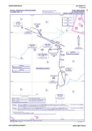
IAC chart of EGNX
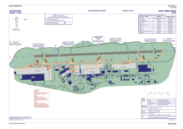
 ADC chart of EGNX
 Satellite view of EGNX
ADC chart of EGNX
Satellite view of EGNX
Sorry, we have no imagery here.
Sorry, we have no imagery here.
Sorry, we have no imagery here.
Sorry, we have no imagery here.
Sorry, we have no imagery here.
Sorry, we have no imagery here.


EGNX - East Midlands
Located in Derby, United Kingdom
ICAO - EGNX, IATA - EMA
Data provided by AirmateGeneral information
Coordinates: N52°49'52" W1°19'40"
Elevation is 306 feet MSL.
View others Airports in England
Operational data
Special qualification required
Current time UTC:
Current local time:
Communications frequencies: [VIEW]
Runways:
| RWY identifier | QFU | Length (ft) | Width (ft) | Surface | LDA (ft) |
| 09 | 88° | 9495 | 148 | ASP | |
| 27 | 268° | 9495 | 148 | ASP |
Airport contact information
Address: Derby United Kingdom
Handlers

Other aviation service providers
Flight schools

Looporder Limited T/A East Midlands Helicopters
Looporder Limited T/A East Midlands Helicopters
sales@eastmidlandshelicopters.com+44 01509856464
Satellite view of EGNX
Sorry, we have no imagery here.
Sorry, we have no imagery here.
Sorry, we have no imagery here.
Sorry, we have no imagery here.
Sorry, we have no imagery here.
Sorry, we have no imagery here.