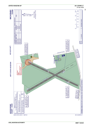
ADC chart of EGNW
 Satellite view of EGNW
Satellite view of EGNW
Sorry, we have no imagery here.
Sorry, we have no imagery here.
Sorry, we have no imagery here.
Sorry, we have no imagery here.
Sorry, we have no imagery here.
Sorry, we have no imagery here.


EGNW - Wickenby
Located in Lincoln, United Kingdom
ICAO - EGNW, IATA -
Data provided by AirmateGeneral information
Coordinates: N53°19'1" W0°20'56"
Elevation is 84 feet MSL.
View others Airports in England
Operational data
Special qualification required
Current time UTC:
Current local time:
Weather at : EGXW - Waddington ( 20 km )
METAR: EGXW 011220Z 11013KT CAVOK 13/03 Q1028 NOSIG RMK BLU BLU
TAF: TAF EGXW 011042Z 0112/0206 11014KT CAVOK
Communications frequencies: [VIEW]
Runways:
| RWY identifier | QFU | Length (ft) | Width (ft) | Surface | LDA (ft) |
| 15 | 150° | 1631 | 59 | UNK | |
| 33 | 330° | 1631 | 59 | UNK | |
| 03 | 25° | 1739 | 59 | Asphalt | |
| 21 | 205° | 1739 | 59 | Asphalt |
Airport contact information
Address: Lincoln United Kingdom
Other aviation service providers
Flight schools

Satellite view of EGNW
Sorry, we have no imagery here.
Sorry, we have no imagery here.
Sorry, we have no imagery here.
Sorry, we have no imagery here.
Sorry, we have no imagery here.
Sorry, we have no imagery here.