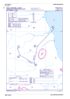
IAC chart of EGNT
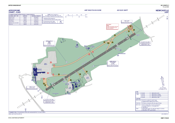
 ADC chart of EGNT
 Satellite view of EGNT
ADC chart of EGNT
Satellite view of EGNT
Sorry, we have no imagery here.
Sorry, we have no imagery here.
Sorry, we have no imagery here.
Sorry, we have no imagery here.
Sorry, we have no imagery here.
Sorry, we have no imagery here.


EGNT - Newcastle
Located in Newcastle-Upon-Tyne, United Kingdom
ICAO - EGNT, IATA - NCL
Data provided by AirmateGeneral information
Coordinates: N55°2'17" W1°41'23"
Elevation is 266 feet MSL.
View others Airports in England
Operational data
Special qualification required
Current time UTC:
Current local time:
Weather
METAR: EGNT 011120Z 11008KT 070V170 CAVOK 14/03 Q1029
TAF: TAF EGNT 011057Z 0112/0212 11010KT CAVOK TEMPO 0119/0210 BKN009 BECMG 0121/0124 VRB03KT TEMPO 0200/0210 7000 PROB30 TEMPO 0203/0208 3000 BR BKN004 BECMG 0209/0212 11010KT
Communications frequencies: [VIEW]
Runways:
| RWY identifier | QFU | Length (ft) | Width (ft) | Surface | LDA (ft) |
| 07 | 65° | 7644 | 148 | ASP | |
| 25 | 245° | 7644 | 148 | ASP |
Airport contact information
Address: Newcastle-Upon-Tyne United Kingdom
Handlers

Other aviation service providers
Flight schools

Northumbria Flying School Limited
Northumbria Flying School Limited
ian@flyingintheuk.co.uk+44 020813970
Satellite view of EGNT
Sorry, we have no imagery here.
Sorry, we have no imagery here.
Sorry, we have no imagery here.
Sorry, we have no imagery here.
Sorry, we have no imagery here.
Sorry, we have no imagery here.