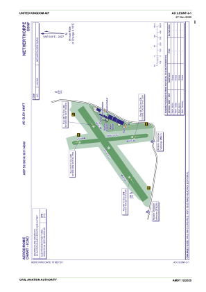
ADC chart of EGNF
 Satellite view of EGNF
Satellite view of EGNF
Sorry, we have no imagery here.
Sorry, we have no imagery here.
Sorry, we have no imagery here.
Sorry, we have no imagery here.
Sorry, we have no imagery here.
Sorry, we have no imagery here.


EGNF - Netherthorpe
Located in Worksop, United Kingdom
ICAO - EGNF, IATA -
Data provided by AirmateGeneral information
Coordinates: N53°19'1" W1°11'46"
Elevation is 248 feet MSL.
View others Airports in England
Operational data
Special qualification required
Current time UTC:
Current local time:
Communications frequencies: [VIEW]
Runways:
| RWY identifier | QFU | Length (ft) | Width (ft) | Surface | LDA (ft) |
| 18 | 175° | 1253 | 59 | Grass | |
| 36 | 355° | 1253 | 59 | Grass | |
| 06 | 55° | 1814 | 118 | Grass | |
| 24 | 235° | 1814 | 118 | Grass |
Airport contact information
Address: Worksop United Kingdom
Other aviation service providers
Flight schools

Stuart Mckinnon T/A Phoenix Flying
Stuart Mckinnon T/A Phoenix Flying
info@phoenix-flying.co.uk+44 07711136505
Satellite view of EGNF
Sorry, we have no imagery here.
Sorry, we have no imagery here.
Sorry, we have no imagery here.
Sorry, we have no imagery here.
Sorry, we have no imagery here.
Sorry, we have no imagery here.