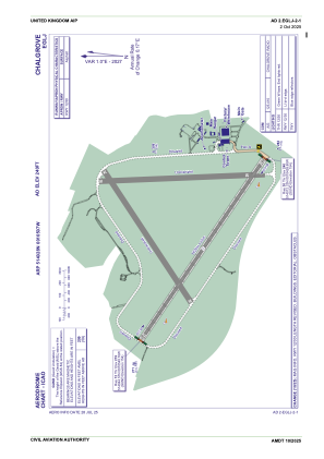
ADC chart of EGLJ
 Satellite view of EGLJ
Satellite view of EGLJ
Sorry, we have no imagery here.
Sorry, we have no imagery here.
Sorry, we have no imagery here.
Sorry, we have no imagery here.
Sorry, we have no imagery here.
Sorry, we have no imagery here.


EGLJ - Chalgrove
Located in Oxford, United Kingdom
ICAO - EGLJ, IATA -
Data provided by AirmateGeneral information
Coordinates: N51°40'28" W1°5'7"
Elevation is 240 feet MSL.
View others Airports in England
Operational data
Special qualification required
Current time UTC:
Current local time:
Weather at : EGUB - Benson ( 7 km )
METAR: EGUB 010650Z 09006KT 9999 SCT011 06/05 Q1026 RMK GRN
TAF: TAF EGUB 010558Z 0107/0115 09010KT 9999 FEW010 TEMPO 0107/0109 SCT010
Communications frequencies: [VIEW]
Runways:
| RWY identifier | QFU | Length (ft) | Width (ft) | Surface | LDA (ft) |
| 12 | 124° | 6004 | 98 | UNK | |
| 30 | 304° | 6004 | 98 | UNK | |
| 06 | 59° | 4347 | 151 | ASP | |
| 18 | 178° | 4186 | 151 | ASP | |
| 24 | 239° | 4347 | 151 | ASP | |
| 36 | 358° | 4186 | 151 | ASP |
Airport contact information
Address: Oxford United Kingdom
Satellite view of EGLJ
Sorry, we have no imagery here.
Sorry, we have no imagery here.
Sorry, we have no imagery here.
Sorry, we have no imagery here.
Sorry, we have no imagery here.
Sorry, we have no imagery here.