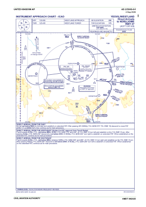
IAC chart of EGHG
 ADC chart of EGHG
 Satellite view of EGHG
ADC chart of EGHG
Satellite view of EGHG
Sorry, we have no imagery here.
Sorry, we have no imagery here.
Sorry, we have no imagery here.
Sorry, we have no imagery here.
Sorry, we have no imagery here.


EGHG - Yeovil/Westland
Located in Yeovil, United Kingdom
ICAO - EGHG, IATA -
Data provided by AirmateGeneral information
Coordinates: N50°56'24" W2°39'32"
Elevation is 202 feet MSL.
View others Airports in England
Operational data
Special qualification required
Current time UTC:
Current local time:
Weather at : EGDY - Yeovilton ( 8 km )
METAR: EGDY 010650Z 10010KT 9999 SCT010 05/04 Q1024 BECMG 9999 FEW010 RMK GRN BECMG BLU
TAF: TAF AMD EGDY 010617Z 0106/0115 10007KT CAVOK TEMPO 0106/0108 SCT010
Communications frequencies: [VIEW]
Runways:
| RWY identifier | QFU | Length (ft) | Width (ft) | Surface | LDA (ft) |
| 09 | 92° | 3904 | 121 | Grass | |
| 27 | 272° | 3904 | 121 | Grass |
Airport contact information
Address: Yeovil United Kingdom
Satellite view of EGHG
Sorry, we have no imagery here.
Sorry, we have no imagery here.
Sorry, we have no imagery here.
Sorry, we have no imagery here.
Sorry, we have no imagery here.