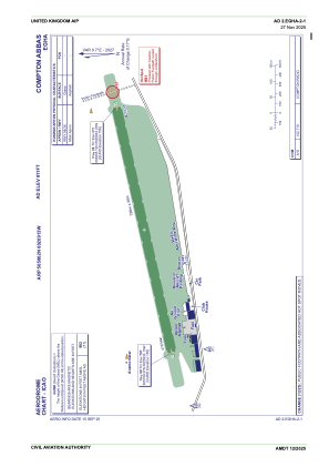
ADC chart of EGHA
 Satellite view of EGHA
Satellite view of EGHA
Sorry, we have no imagery here.
Sorry, we have no imagery here.
Sorry, we have no imagery here.
Sorry, we have no imagery here.
Sorry, we have no imagery here.
Sorry, we have no imagery here.


EGHA - Compton Abbas
Located in Shaftesbury, United Kingdom
ICAO - EGHA, IATA -
Data provided by AirmateGeneral information
Coordinates: N50°58'2" W2°9'13"
Elevation is 811 feet MSL.
View others Airports in England
Operational data
Special qualification required
Current time UTC:
Current local time:
Weather at : EGHH - Bournemouth ( 30 km )
METAR: EGHH 011020Z 10013KT CAVOK 12/05 Q1024
TAF: TAF EGHH 010800Z 0109/0118 09010KT CAVOK PROB30 TEMPO 0110/0118 12015G25KT
Communications frequencies: [VIEW]
Runways:
| RWY identifier | QFU | Length (ft) | Width (ft) | Surface | LDA (ft) |
| 08 | 77° | 2621 | 98 | Grass | |
| 26 | 257° | 2621 | 98 | Grass |
Airport contact information
Address: Shaftesbury United Kingdom

Satellite view of EGHA
Sorry, we have no imagery here.
Sorry, we have no imagery here.
Sorry, we have no imagery here.
Sorry, we have no imagery here.
Sorry, we have no imagery here.
Sorry, we have no imagery here.