ADC chart of EGCE15
 Satellite view of EGCE15
Satellite view of EGCE15
Sorry, we have no imagery here.
Sorry, we have no imagery here.
Sorry, we have no imagery here.
Sorry, we have no imagery here.
Sorry, we have no imagery here.
Sorry, we have no imagery here.


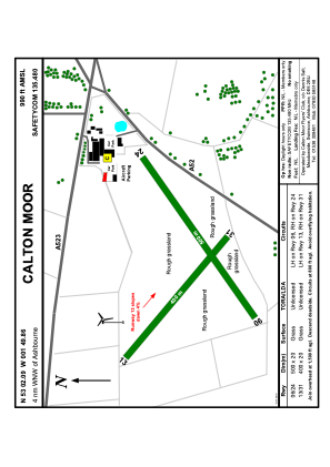
EGCE15 - Calton Moor
Located in , United Kingdom
ICAO - , IATA -
Data provided by AirmateGeneral information
Coordinates: N53°1'58" W1°50'6"
Elevation is 990 feet MSL.
Magnetic variation is -1° East View others Airports in England
Operational data
Special qualification required
Current time UTC:
Current local time:
Weather at : EGNX - East Midlands ( 41 km )
METAR: EGNX 010020Z 12007KT CAVOK 08/05 Q1028
TAF: TAF EGNX 312252Z 0100/0124 12008KT CAVOK TEMPO 0103/0110 BKN006 PROB30 TEMPO 0104/0108 0600 FG BKN001 BECMG 0109/0112 08012KT BECMG 0121/0124 VRB03KT
Communications frequencies: [VIEW]
Runways:
| RWY identifier | QFU | Length (ft) | Width (ft) | Surface | LDA (ft) |
| 24 | 0° | 1640 | 65 | GRASS | |
| 06 | 0° | 1640 | 65 | GRASS |
Airport contact information
Address: United Kingdom
Satellite view of EGCE15
Sorry, we have no imagery here.
Sorry, we have no imagery here.
Sorry, we have no imagery here.
Sorry, we have no imagery here.
Sorry, we have no imagery here.
Sorry, we have no imagery here.