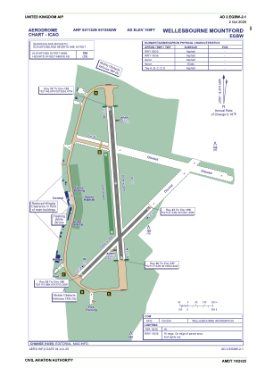
ADC chart of EGBW
 Satellite view of EGBW
Satellite view of EGBW
Sorry, we have no imagery here.
Sorry, we have no imagery here.
Sorry, we have no imagery here.
Sorry, we have no imagery here.
Sorry, we have no imagery here.
Sorry, we have no imagery here.


EGBW - Wellesbourne Mountford
Located in Stratford-On-Avon, United Kingdom
ICAO - EGBW, IATA -
Data provided by AirmateGeneral information
Coordinates: N52°11'32" W1°36'52"
Elevation is 159 feet MSL.
View others Airports in England
Operational data
Special qualification required
Current time UTC:
Current local time:
Communications frequencies: [VIEW]
Runways:
| RWY identifier | QFU | Length (ft) | Width (ft) | Surface | LDA (ft) |
| 05 | 46° | 1926 | 59 | ASP | |
| 23 | 226° | 1926 | 59 | ASP | |
| 18 | 176° | 3009 | 75 | ASP | |
| 36 | 356° | 3009 | 75 | ASP |
Airport contact information
Address: Stratford-On-Avon United Kingdom
Other aviation service providers
Flight schools

South Warwickshire School Of Flying Limited
South Warwickshire School Of Flying Limited
ops@southwarwickshireflyingschool.com+44 01789840094
Satellite view of EGBW
Sorry, we have no imagery here.
Sorry, we have no imagery here.
Sorry, we have no imagery here.
Sorry, we have no imagery here.
Sorry, we have no imagery here.
Sorry, we have no imagery here.