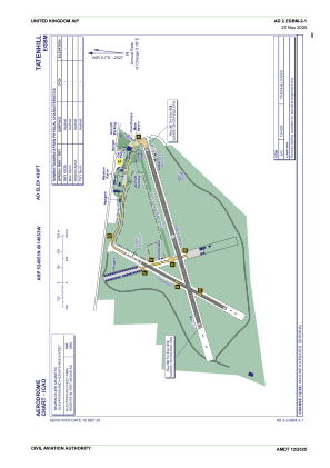
ADC chart of EGBM
 Satellite view of EGBM
Satellite view of EGBM
Sorry, we have no imagery here.
Sorry, we have no imagery here.
Sorry, we have no imagery here.
Sorry, we have no imagery here.
Sorry, we have no imagery here.
Sorry, we have no imagery here.


EGBM - Tatenhill
Located in Burton-On-Trent, United Kingdom
ICAO - EGBM, IATA -
Data provided by AirmateGeneral information
Coordinates: N52°48'51" W1°45'53"
Elevation is 439 feet MSL.
View others Airports in England
Operational data
Special qualification required
Current time UTC:
Current local time:
Weather at : EGNX - East Midlands ( 29 km )
METAR: EGNX 011620Z 07014KT CAVOK 14/04 Q1024
TAF: TAF EGNX 011053Z 0112/0212 10012KT CAVOK PROB30 0202/0208 9000 PROB30 TEMPO 0209/0212 08015G25KT
Communications frequencies: [VIEW]
Runways:
| RWY identifier | QFU | Length (ft) | Width (ft) | Surface | LDA (ft) |
| 08 | 73° | 3904 | 92 | Asphalt | |
| 26 | 253° | 3904 | 92 | Asphalt | |
| 03 | 0° | 2067 | 59 | UNK | |
| 21 | 0° | 2067 | 59 | UNK |
Airport contact information
Address: Burton-On-Trent United Kingdom
Other aviation service providers
Flight schools

Craig Padfield T/A Central Flight Training
Craig Padfield T/A Central Flight Training
info@centralflighttraining.com+44 07870578328
Satellite view of EGBM
Sorry, we have no imagery here.
Sorry, we have no imagery here.
Sorry, we have no imagery here.
Sorry, we have no imagery here.
Sorry, we have no imagery here.
Sorry, we have no imagery here.