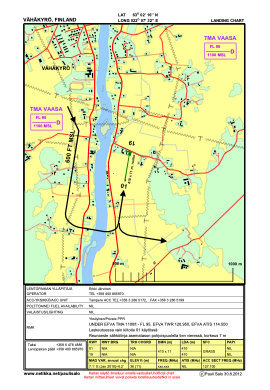
VAC chart of EFVAHA
 Satellite view of EFVAHA
Satellite view of EFVAHA
Sorry, we have no imagery here.
Sorry, we have no imagery here.
Sorry, we have no imagery here.
Sorry, we have no imagery here.
Sorry, we have no imagery here.


EFVAHA - Vahakyro
Located in Vaasa, Finland
ICAO - , IATA -
Data provided by AirmateGeneral information
Coordinates: N63°2'16" E22°7'32"
Elevation is 36 feet MSL.
Magnetic variation is 9° East View others Airports in Western Finland
Operational data
Special qualification required
Current time UTC:
Current local time:
Weather at : EFVA - Vaasa ( 18 km )
METAR: EFVA 071220Z AUTO 01014KT CAVOK 06/M06 Q1025
TAF: TAF EFVA 071124Z 0712/0812 01014KT CAVOK BECMG 0717/0719 VRB02KT
Communications frequencies: [VIEW]
Runways:
| RWY identifier | QFU | Length (ft) | Width (ft) | Surface | LDA (ft) |
| 36 | 6° | 959 | 29 | GRAS | |
| 18 | 186° | 959 | 29 | GRAS |
Airport contact information
Address: Vaasa Finland
Satellite view of EFVAHA
Sorry, we have no imagery here.
Sorry, we have no imagery here.
Sorry, we have no imagery here.
Sorry, we have no imagery here.
Sorry, we have no imagery here.