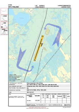
VAC chart of EFIT
 Satellite view of EFIT
Satellite view of EFIT
Sorry, we have no imagery here.
Sorry, we have no imagery here.
Sorry, we have no imagery here.
Sorry, we have no imagery here.
Sorry, we have no imagery here.
Sorry, we have no imagery here.


EFIT - Kitee
Located in , Finland
ICAO - EFIT, IATA - KTQ
Data provided by AirmateGeneral information
Coordinates: N62°9'58" E30°4'25"
Elevation is 364 feet MSL.
View others Airports in Eastern Finland
Operational data
Special qualification required
Current time UTC:
Current local time:
Weather at : EFJO - Joensuu ( 59 km )
METAR: EFJO 110520Z AUTO 06008KT 010V090 2600 -SN SCT004 OVC025 M05/M07 Q0994
TAF: TAF AMD EFJO 110434Z 1104/1112 08008KT 3000 -SN FEW004 OVC015 TEMPO 1104/1106 1300 SN BKN004 BECMG 1106/1108 02010KT 8000 TEMPO 1108/1110 6000
Communications frequencies: [VIEW]
Runways:
| RWY identifier | QFU | Length (ft) | Width (ft) | Surface | LDA (ft) |
| 01 | 19° | 4921 | 98 | ASP | |
| 19 | 199° | 4921 | 98 | ASP |
Airport contact information
Address: Finland
Satellite view of EFIT
Sorry, we have no imagery here.
Sorry, we have no imagery here.
Sorry, we have no imagery here.
Sorry, we have no imagery here.
Sorry, we have no imagery here.
Sorry, we have no imagery here.