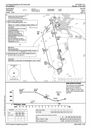
IAC chart of EDRY
 Satellite view of EDRY
Satellite view of EDRY
Sorry, we have no imagery here.
Sorry, we have no imagery here.
Sorry, we have no imagery here.
Sorry, we have no imagery here.
Sorry, we have no imagery here.
Sorry, we have no imagery here.


EDRY - Speyer
Located in Speyer, Germany
ICAO - EDRY, IATA - ZQC
Data provided by AirmateGeneral information
Coordinates: N49°18'8" E8°27'6"
Elevation is 312 feet MSL.
Magnetic variation is 3.0000° East View others Airports in Rhineland-Palatinate
Operational data
Special qualification required
Current time UTC:
Current local time:
Weather at : EDFM - Mannheim City ( 19 km )
METAR: EDFM 210720Z VRB02KT CAVOK 18/09 Q1014
TAF: TAF EDFM 210500Z 2106/2115 VRB02KT CAVOK TEMPO 2111/2115 29020G30KT 4000 TSRA BKN030CB
Communications frequencies: [VIEW]
Runways:
| RWY identifier | QFU | Length (ft) | Width (ft) | Surface | LDA (ft) |
| 16 | 0° | 5502 | 98 | UNK | |
| 34 | 0° | 5502 | 98 | UNK |
Airport contact information
Address: Speyer Germany
Other aviation service providers
Aviation club (not for profit)

Satellite view of EDRY
Sorry, we have no imagery here.
Sorry, we have no imagery here.
Sorry, we have no imagery here.
Sorry, we have no imagery here.
Sorry, we have no imagery here.
Sorry, we have no imagery here.