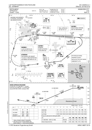
IAC chart of EDFM
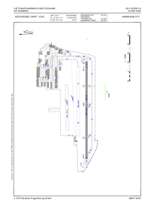
 ADC chart of EDFM
 Satellite view of EDFM
ADC chart of EDFM
Satellite view of EDFM
Sorry, we have no imagery here.
Sorry, we have no imagery here.
Sorry, we have no imagery here.
Sorry, we have no imagery here.
Sorry, we have no imagery here.
Sorry, we have no imagery here.


EDFM - Mannheim City
Located in Mannheim, Germany
ICAO - EDFM, IATA - MHG
Data provided by AirmateGeneral information
Coordinates: N49°28'22" E8°30'51"
Elevation is 305 feet MSL.
Magnetic variation is 2.3000° East View others Airports in Baden-Württemberg
Operational data
Special qualification required
Current time UTC:
Current local time:
Weather
METAR: EDFM 100150Z AUTO 33005KT 9999 // BKN240/// 09/02 Q1025
TAF: TAF EDFM 091700Z 0918/0921 03003KT CAVOK
Communications frequencies: [VIEW]
Runways:
| RWY identifier | QFU | Length (ft) | Width (ft) | Surface | LDA (ft) |
| 09 | 93° | 3497 | 82 | ASP | |
| 27 | 273° | 3497 | 82 | ASP | |
| 09G | 0° | 0 | 0 | UNK | |
| 27G | 0° | 0 | 0 | UNK |
Airport contact information
Address: Mannheim Germany
Other aviation service providers
Aviation club (not for profit)

Flugschule Des Badisch-Pfälzischen Flugsportvereins E.V .
Flugschule Des Badisch-Pfälzischen Flugsportvereins E.V .
Satellite view of EDFM
Sorry, we have no imagery here.
Sorry, we have no imagery here.
Sorry, we have no imagery here.
Sorry, we have no imagery here.
Sorry, we have no imagery here.
Sorry, we have no imagery here.