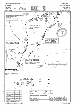
EDAZ - Schoenhagen
Located in Schoenhagen, Germany
ICAO - EDAZ, IATA - QXH
Data provided by AirmateGeneral information
Coordinates: N52°12'14" E13°9'36"
Elevation is 152 feet MSL.
Magnetic variation is 4.6900° East View others Airports in Brandenburg
Operational data
Special qualification required
Current time UTC:
Current local time:
Weather at : EDDB - Berlin Brandenburg ( 29 km )
METAR: EDDB 231050Z AUTO 23010KT 9999 OVC023 03/M00 Q1019 NOSIG
TAF: TAF EDDB 230500Z 2306/2406 24011KT 9999 SCT020 TEMPO 2306/2312 BKN012 PROB30 TEMPO 2306/2312 2500 -SHSN BKN008 BKN015CB BECMG 2316/2319 18010KT TEMPO 2400/2406 18015G25KT RA
Communications frequencies: [VIEW]
Runways:
| RWY identifier | QFU | Length (ft) | Width (ft) | Surface | LDA (ft) |
| 07 | 76° | 4954 | 75 | ASPH | 4396 |
| 25 | 256° | 4954 | 75 | ASPH | 4167 |
| 12 | 119° | 2297 | 59 | ASPH | 2297 |
| 30 | 299° | 2297 | 59 | ASPH | 2297 |
| 12G | 119° | 2493 | 131 | GRASS | 2051 |
| 30G | 299° | 2493 | 131 | GRASS | 2329 |
Airport contact information
Address: Schoenhagen Germany
Other aviation service providers
Flight schools
Aviation club (not for profit)
Luftsport-Landesverband Brandenburg E.V.
Luftsport-Landesverband Brandenburg E.V.
info@luftsport-bb.de+493373117143
+4915233903842
+4915233903842
Hanseatischer Fliegerclub Berlin E.V.
Hanseatischer Fliegerclub Berlin E.V.
info@hfc-berlin.de+4933731320020


