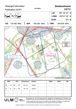
VAC chart of EBTN
 Satellite view of EBTN
Satellite view of EBTN
Sorry, we have no imagery here.
Sorry, we have no imagery here.
Sorry, we have no imagery here.
Sorry, we have no imagery here.
Sorry, we have no imagery here.
Sorry, we have no imagery here.


EBTN - Hoegaarden
Located in Goetsenhoven, Belgium
ICAO - EBTN, IATA -
Data provided by AirmateGeneral information
Coordinates: N50°46'54" E4°57'28"
Elevation is 238 feet MSL.
Magnetic variation is 2° East View others Airports in Flemish Brabant
Operational data
Special qualification required
Current time UTC:
Current local time:
Communications frequencies: [VIEW]
Runways:
| RWY identifier | QFU | Length (ft) | Width (ft) | Surface | LDA (ft) |
| 06 | 60° | 2388 | 98 | ASPH | 1847 |
| 24 | 240° | 2388 | 98 | ASPH | 1847 |
| 17 | 170° | 2559 | 98 | ASPH | 1837 |
| 35 | 350° | 2559 | 98 | ASPH | 1837 |
Airport contact information
Address: Goetsenhoven Belgium

Satellite view of EBTN
Sorry, we have no imagery here.
Sorry, we have no imagery here.
Sorry, we have no imagery here.
Sorry, we have no imagery here.
Sorry, we have no imagery here.
Sorry, we have no imagery here.