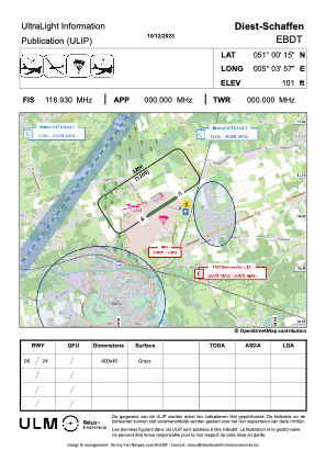
VAC chart of EBDT
 Satellite view of EBDT
Satellite view of EBDT
Sorry, we have no imagery here.
Sorry, we have no imagery here.
Sorry, we have no imagery here.
Sorry, we have no imagery here.
Sorry, we have no imagery here.
Sorry, we have no imagery here.


EBDT - Diest / Schaffen
Located in Diest, Belgium
ICAO - EBDT, IATA -
Data provided by AirmateGeneral information
Coordinates: N51°0'5" E5°3'43"
Elevation is 92 feet MSL.
View others Airports in Flemish Brabant
Operational data
Special qualification required
Current time UTC:
Current local time:
Weather
METAR: EBDT 120055Z AUTO VRB02KT 9999 NCD 10/06 Q1016 BLU
Communications frequencies: [VIEW]
Runways:
| RWY identifier | QFU | Length (ft) | Width (ft) | Surface | LDA (ft) |
| 06 | 0° | 1969 | 98 | GRASS | |
| 24 | 0° | 1969 | 98 | GRASS |
Airport contact information
Address: Diest Belgium
Satellite view of EBDT
Sorry, we have no imagery here.
Sorry, we have no imagery here.
Sorry, we have no imagery here.
Sorry, we have no imagery here.
Sorry, we have no imagery here.
Sorry, we have no imagery here.