ADC chart of E70
 Satellite view of E70
Satellite view of E70
Sorry, we have no imagery here.
Sorry, we have no imagery here.
Sorry, we have no imagery here.
Sorry, we have no imagery here.
Sorry, we have no imagery here.
Sorry, we have no imagery here.


E70 - Huber Airpark Civic Club Llc
Located in Seguin, United States
ICAO - E70, IATA -
Data provided by AirmateGeneral information
Coordinates: N29°36'9" W97°59'26"
Elevation is 556 feet MSL.
Magnetic variation is 06° East View others Airports in Texas
Operational data
Special qualification required
Current time UTC:
Current local time:
Weather at : KSEQ - Randolph Afb Aux ( 9 km )
METAR: KSEQ 021155Z AUTO 17010KT 8SM BKN018 OVC025 24/22 A2951 RMK AO2 SLP988 T02420219 10245 20222 56002
Communications frequencies: [VIEW]
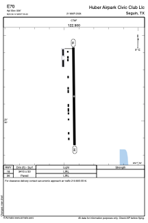
Runways:
| RWY identifier | QFU | Length (ft) | Width (ft) | Surface | LDA (ft) |
| 18 | 0° | 3415 | 50 | ASPH | |
| 36 | 0° | 3415 | 50 | ASPH |
Airport contact information
Address: Seguin United States
Other aviation service providers
Flight schools

Satellite view of E70
Sorry, we have no imagery here.
Sorry, we have no imagery here.
Sorry, we have no imagery here.
Sorry, we have no imagery here.
Sorry, we have no imagery here.
Sorry, we have no imagery here.