ADC chart of E57
 Satellite view of E57
Satellite view of E57
Sorry, we have no imagery here.
Sorry, we have no imagery here.
Sorry, we have no imagery here.
Sorry, we have no imagery here.
Sorry, we have no imagery here.
Sorry, we have no imagery here.


E57 - Denver City
Located in Denver City, United States
ICAO - E57, IATA -
Data provided by AirmateGeneral information
Coordinates: N32°58'29" W102°50'42"
Elevation is 3575 feet MSL.
Magnetic variation is 09° East View others Airports in Texas
Operational data
Special qualification required
Current time UTC:
Current local time:
Weather at : KGNC - Gaines County ( 38 km )
METAR: KGNC 020835Z AUTO 32019G32KT 7SM CLR 14/M04 A2965 RMK AO2 T01401045
Communications frequencies: [VIEW]
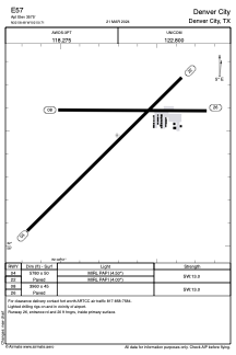
Runways:
| RWY identifier | QFU | Length (ft) | Width (ft) | Surface | LDA (ft) |
| 04 | 46° | 5780 | 50 | ASPH | |
| 22 | 226° | 5780 | 50 | ASPH | |
| 08 | 89° | 3960 | 45 | ASPH | |
| 26 | 269° | 3960 | 45 | ASPH |
Airport contact information
Address: Denver City United States
Satellite view of E57
Sorry, we have no imagery here.
Sorry, we have no imagery here.
Sorry, we have no imagery here.
Sorry, we have no imagery here.
Sorry, we have no imagery here.
Sorry, we have no imagery here.