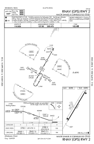
IAC chart of E42
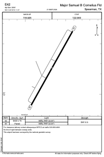
 ADC chart of E42
 Satellite view of E42
ADC chart of E42
Satellite view of E42
Sorry, we have no imagery here.
Sorry, we have no imagery here.
Sorry, we have no imagery here.
Sorry, we have no imagery here.
Sorry, we have no imagery here.
Sorry, we have no imagery here.


E42 - Major Samuel B Cornelius Fld
Located in Spearman, United States
ICAO - E42, IATA -
Data provided by AirmateGeneral information
Coordinates: N36°13'16" W101°11'40"
Elevation is 3090 feet MSL.
Magnetic variation is 09° East View others Airports in Texas
Operational data
Special qualification required
Current time UTC:
Current local time:
Weather at : KPYX - Perryton Ochiltree County ( 45 km )
METAR: KPYX 021155Z AUTO 26015KT 10SM CLR 08/M06 A2947 RMK AO2 70001 T00821062 10164 20082
Communications frequencies: [VIEW]
Runways:
| RWY identifier | QFU | Length (ft) | Width (ft) | Surface | LDA (ft) |
| 02 | 29° | 5022 | 75 | ASPH | |
| 20 | 209° | 5022 | 75 | ASPH |
Airport contact information
Address: Spearman United States
Satellite view of E42
Sorry, we have no imagery here.
Sorry, we have no imagery here.
Sorry, we have no imagery here.
Sorry, we have no imagery here.
Sorry, we have no imagery here.
Sorry, we have no imagery here.