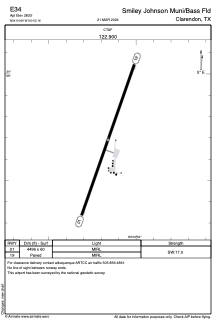
ADC chart of E34
 Satellite view of E34
Satellite view of E34
Sorry, we have no imagery here.
Sorry, we have no imagery here.
Sorry, we have no imagery here.
Sorry, we have no imagery here.
Sorry, we have no imagery here.
Sorry, we have no imagery here.


E34 - Smiley Johnson Muni/Bass Fld
Located in Clarendon, United States
ICAO - E34, IATA -
Data provided by AirmateGeneral information
Coordinates: N34°54'41" W100°52'10"
Elevation is 2833 feet MSL.
Magnetic variation is 08° East View others Airports in Texas
Operational data
Special qualification required
Current time UTC:
Current local time:
Weather at : KCDS - Childress Muni ( 75 km )
METAR: KCDS 021253Z AUTO 29015G23KT 10SM CLR 13/M06 A2957 RMK AO2 SLP992 T01331061
TAF: KCDS 021120Z 0212/0312 32011KT P6SM BKN100 FM021600 26015KT P6SM SCT100 FM030000 30011KT P6SM OVC060
Communications frequencies: [VIEW]
Runways:
| RWY identifier | QFU | Length (ft) | Width (ft) | Surface | LDA (ft) |
| 01 | 19° | 4496 | 60 | ASPH | |
| 19 | 199° | 4496 | 60 | ASPH |
Airport contact information
Address: Clarendon United States
Satellite view of E34
Sorry, we have no imagery here.
Sorry, we have no imagery here.
Sorry, we have no imagery here.
Sorry, we have no imagery here.
Sorry, we have no imagery here.
Sorry, we have no imagery here.