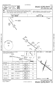
IAC chart of E01
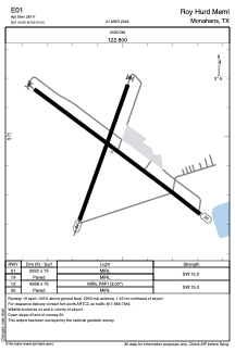
 ADC chart of E01
 Satellite view of E01
ADC chart of E01
Satellite view of E01
Sorry, we have no imagery here.
Sorry, we have no imagery here.
Sorry, we have no imagery here.
Sorry, we have no imagery here.
Sorry, we have no imagery here.
Sorry, we have no imagery here.


E01 - Roy Hurd Meml
Located in Monahans, United States
ICAO - E01, IATA -
Data provided by AirmateGeneral information
Coordinates: N31°34'57" W102°54'33"
Elevation is 2615 feet MSL.
Magnetic variation is 09° East View others Airports in Texas
Operational data
Special qualification required
Current time UTC:
Current local time:
Weather at : KINK - Winkler County ( 35 km )
METAR: KINK 021253Z AUTO 03008KT 10SM CLR 12/M07 A2967 RMK AO2 SLP009 T01221067 $
TAF: KINK 021143Z 0212/0312 36012KT P6SM SCT060 SCT250 FM021400 31010KT P6SM SCT250 FM021700 28013G20KT P6SM SCT150 BKN250 FM030000 31007KT P6SM SCT100 BKN200
Communications frequencies: [VIEW]
Runways:
| RWY identifier | QFU | Length (ft) | Width (ft) | Surface | LDA (ft) |
| 01 | 20° | 2922 | 75 | ASPH | |
| 19 | 200° | 2922 | 75 | ASPH | |
| 12 | 127° | 4268 | 75 | ASPH | |
| 30 | 307° | 4268 | 75 | ASPH |
Airport contact information
Address: Monahans United States
Satellite view of E01
Sorry, we have no imagery here.
Sorry, we have no imagery here.
Sorry, we have no imagery here.
Sorry, we have no imagery here.
Sorry, we have no imagery here.
Sorry, we have no imagery here.