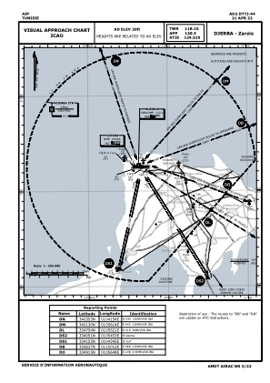
VAC chart of DTTJ
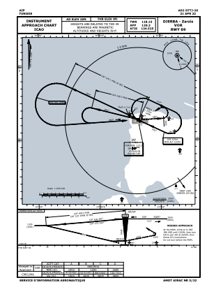
 IAC chart of DTTJ
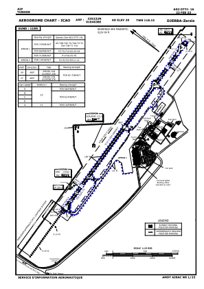
 ADC chart of DTTJ
 Satellite view of DTTJ
IAC chart of DTTJADC chart of DTTJ
Satellite view of DTTJ
Sorry, we have no imagery here.
Sorry, we have no imagery here.
Sorry, we have no imagery here.
Sorry, we have no imagery here.
Sorry, we have no imagery here.
Sorry, we have no imagery here.


DTTJ - Djerba/Zarzis
Located in Djerba, Tunisia
ICAO - DTTJ, IATA - DJE
Data provided by AirmateGeneral information
Coordinates: N33°52'32" E10°46'38"
Elevation is 20 feet MSL.
Magnetic variation is 3° East View others Airports in Medenine Governorate
Operational data
Special qualification required
Current time UTC:
Current local time:
Weather
METAR: DTTJ 120230Z 14005KT 8000 FEW020 16/15 Q1017 NOSIG
TAF: TAF DTTJ 112300Z 1200/1224 14006KT 8000 FEW020 BECMG 1204/1206 VRB02KT BECMG 1214/1216 10015KT
Communications frequencies: [VIEW]
Runways:
| RWY identifier | QFU | Length (ft) | Width (ft) | Surface | LDA (ft) |
| 09 | 88° | 10210 | 148 | ASP | |
| 27 | 268° | 10210 | 148 | ASP |
Airport contact information
Address: Djerba Tunisia
Satellite view of DTTJ
Sorry, we have no imagery here.
Sorry, we have no imagery here.
Sorry, we have no imagery here.
Sorry, we have no imagery here.
Sorry, we have no imagery here.
Sorry, we have no imagery here.