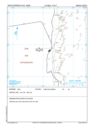
VAC chart of DRZD
 Satellite view of DRZD
Satellite view of DRZD
Sorry, we have no imagery here.
Sorry, we have no imagery here.
Sorry, we have no imagery here.
Sorry, we have no imagery here.
Sorry, we have no imagery here.
Sorry, we have no imagery here.


DRZD - Dirkou
Located in , Niger
ICAO - DRZD, IATA -
Data provided by AirmateGeneral information
Coordinates: N18°58'8" E12°52'8"
Elevation is 1273 feet MSL.
View others Airports in Agadez Region
Operational data
Special qualification required
Current time UTC:
Current local time:
Weather at : - ( 0 km )
METAR: ULLI 110451Z 20004MPS 120V260 8000 3400SW -SHSN FEW011 BKN018CB OVC036 M02/M03 Q0994 R28L/590531 NOSIG
Communications frequencies: [VIEW]
Runways:
| RWY identifier | QFU | Length (ft) | Width (ft) | Surface | LDA (ft) |
| 04 | 41° | 5249 | 131 | ASP | |
| 22 | 221° | 5249 | 131 | ASP |
Airport contact information
Address: Niger
Satellite view of DRZD
Sorry, we have no imagery here.
Sorry, we have no imagery here.
Sorry, we have no imagery here.
Sorry, we have no imagery here.
Sorry, we have no imagery here.
Sorry, we have no imagery here.