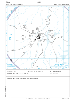
VAC chart of DRZA
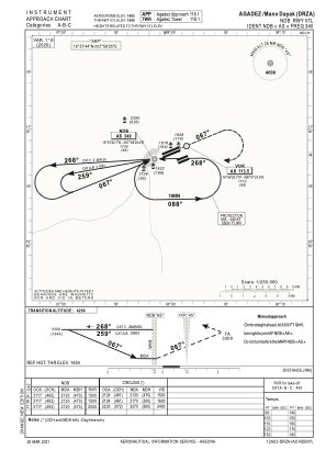
 IAC chart of DRZA
 Satellite view of DRZA
IAC chart of DRZA
Satellite view of DRZA
Sorry, we have no imagery here.
Sorry, we have no imagery here.
Sorry, we have no imagery here.
Sorry, we have no imagery here.
Sorry, we have no imagery here.
Sorry, we have no imagery here.


DRZA - Agadez/Mano Dayak
Located in Agadez, Niger
ICAO - DRZA, IATA - AJY
Data provided by AirmateGeneral information
Coordinates: N16°57'44" E7°59'25"
Elevation is 1660 feet MSL.
View others Airports in Agadez Region
Operational data
Special qualification required
Current time UTC:
Current local time:
Weather
METAR: DRZA 111100Z 10019KT CAVOK 37/M01 Q1014
TAF: TAF DRZA 111100Z 1112/1212 08010KT 8000 NSC TEMPO 1208/1214 12022KT 3500 BLDU
Communications frequencies: [VIEW]
Runways:
| RWY identifier | QFU | Length (ft) | Width (ft) | Surface | LDA (ft) |
| 07L | 68° | 9843 | 98 | UNK | |
| 25R | 248° | 9843 | 98 | UNK | |
| 07R | 68° | 6791 | 98 | UNK | |
| 25L | 248° | 6791 | 98 | UNK |
Airport contact information
Address: Agadez Niger
Satellite view of DRZA
Sorry, we have no imagery here.
Sorry, we have no imagery here.
Sorry, we have no imagery here.
Sorry, we have no imagery here.
Sorry, we have no imagery here.
Sorry, we have no imagery here.