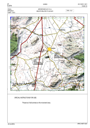
VAC chart of DAOV
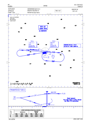
 IAC chart of DAOV
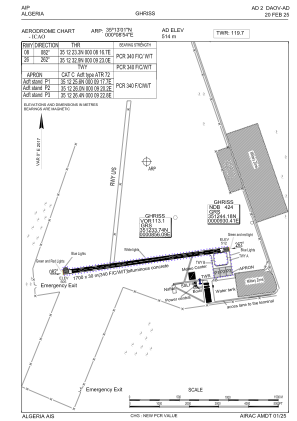
 ADC chart of DAOV
 Satellite view of DAOV

IAC chart of DAOVADC chart of DAOV
Satellite view of DAOV
Sorry, we have no imagery here.
Sorry, we have no imagery here.
Sorry, we have no imagery here.
Sorry, we have no imagery here.
Sorry, we have no imagery here.
Sorry, we have no imagery here.


DAOV - Ghriss
Located in Ghriss, Algeria
ICAO - DAOV, IATA - MUW
Data provided by AirmateGeneral information
Coordinates: N35°13'1" E0°8'54"
Elevation is 1686 feet MSL.
View others Airports in Mascara Province
Operational data
Special qualification required
Current time UTC:
Current local time:
Weather
TAF: TAF DAOV 042000Z 0421/0506 19020KT 8000 SCT026 SCT100 TEMPO 0421/0501 19020G35KT 5000 TSRA FEW026CB
Communications frequencies: [VIEW]
Runways:
| RWY identifier | QFU | Length (ft) | Width (ft) | Surface | LDA (ft) |
| 08 | 82° | 5577 | 98 | ASP | |
| 26 | 262° | 5577 | 98 | ASP |
Airport contact information
Address: Ghriss Algeria
Satellite view of DAOV
Sorry, we have no imagery here.
Sorry, we have no imagery here.
Sorry, we have no imagery here.
Sorry, we have no imagery here.
Sorry, we have no imagery here.
Sorry, we have no imagery here.