ADC chart of D64
 Satellite view of D64
Satellite view of D64
Sorry, we have no imagery here.
Sorry, we have no imagery here.
Sorry, we have no imagery here.
Sorry, we have no imagery here.
Sorry, we have no imagery here.
Sorry, we have no imagery here.


D64 - Westhope Muni
Located in Westhope, United States
ICAO - D64, IATA -
Data provided by AirmateGeneral information
Coordinates: N48°54'47" W101°2'1"
Elevation is 1492 feet MSL.
Magnetic variation is 10° East View others Airports in North Dakota
Operational data
Special qualification required
Current time UTC:
Current local time:
Weather at : KMIB - Minot Afb ( 60 km )
METAR: KMIB 141755Z 33016KT 10SM SCT023 BKN140 24/18 A2972 RMK RAE49 SLP062 T02380180 10239 20202 51020
TAF: TAF KMIB 141700Z 1417/1523 32012G18KT 9999 BKN010 QNH2970INS BECMG 1418/1419 33012G18KT 9999 BKN040 QNH2974INS BECMG 1420/1421 33012G18KT 9999 SCT050 QNH2978INS BECMG 1503/1504 32009KT 9999 FEW080 QNH2985INS BECMG 1514/1515 01009KT 9999 SCT050 QNH2999INS TX21/1420Z TN12/1512Z
Communications frequencies: [VIEW]
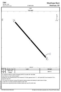
Runways:
| RWY identifier | QFU | Length (ft) | Width (ft) | Surface | LDA (ft) |
| 14 | 0° | 3000 | 60 | ASPH | |
| 32 | 0° | 3000 | 60 | ASPH |
Airport contact information
Address: Westhope United States
Satellite view of D64
Sorry, we have no imagery here.
Sorry, we have no imagery here.
Sorry, we have no imagery here.
Sorry, we have no imagery here.
Sorry, we have no imagery here.
Sorry, we have no imagery here.