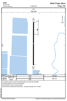
ADC chart of D54
 Satellite view of D54
Satellite view of D54
Sorry, we have no imagery here.
Sorry, we have no imagery here.
Sorry, we have no imagery here.
Sorry, we have no imagery here.
Sorry, we have no imagery here.
Sorry, we have no imagery here.


D54 - West Fargo Muni
Located in Fargo, United States
ICAO - D54, IATA -
Data provided by AirmateGeneral information
Coordinates: N46°54'1" W96°55'7"
Elevation is 896 feet MSL.
Magnetic variation is 06° East View others Airports in North Dakota
Operational data
Special qualification required
Current time UTC:
Current local time:
Weather at : KFAR - Hector Intl ( 8 km )
METAR: KFAR 250953Z 17005KT 10SM CLR 18/17 A2997 RMK AO2 SLP148 T01830172
TAF: KFAR 250520Z 2506/2606 17004KT P6SM SKC FM250900 17005KT P6SM SKC TEMPO 2509/2513 VRB02KT 2SM BR FM251600 18011G17KT P6SM SKC FM252000 17015G22KT P6SM SKC
Communications frequencies: [VIEW]
Runways:
| RWY identifier | QFU | Length (ft) | Width (ft) | Surface | LDA (ft) |
| 18 | 0° | 3300 | 50 | ASPH | |
| 36 | 0° | 3300 | 50 | ASPH |
Airport contact information
Address: Fargo United States
Satellite view of D54
Sorry, we have no imagery here.
Sorry, we have no imagery here.
Sorry, we have no imagery here.
Sorry, we have no imagery here.
Sorry, we have no imagery here.
Sorry, we have no imagery here.