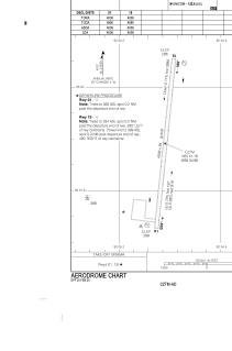
ADC chart of CZTM
 Satellite view of CZTM
Satellite view of CZTM
Sorry, we have no imagery here.
Sorry, we have no imagery here.
Sorry, we have no imagery here.
Sorry, we have no imagery here.
Sorry, we have no imagery here.
Sorry, we have no imagery here.


CZTM - Shamattawa
Located in , Canada
ICAO - CZTM, IATA - ZTM
Data provided by AirmateGeneral information
Coordinates: N55°51'47" W92°4'53"
Elevation is 295 feet MSL.
Magnetic variation is -3.4567° East View others Airports in Manitoba
Operational data
Special qualification required
Current time UTC:
Current local time:
Weather at : - ( 0 km )
METAR: USDD 100847Z 21007MPS 8000 -SHSN SCT009CB 01/M02 Q0996 R22/290060 NOSIG RMK QFE742/0990
Communications frequencies: [VIEW]
Runways:
| RWY identifier | QFU | Length (ft) | Width (ft) | Surface | LDA (ft) |
| 01 | 6° | 4006 | 94 | GRAVE | 4006 |
| 19 | 186° | 4006 | 94 | GRAVE | 4006 |
Airport contact information
Address: Canada
Satellite view of CZTM
Sorry, we have no imagery here.
Sorry, we have no imagery here.
Sorry, we have no imagery here.
Sorry, we have no imagery here.
Sorry, we have no imagery here.
Sorry, we have no imagery here.