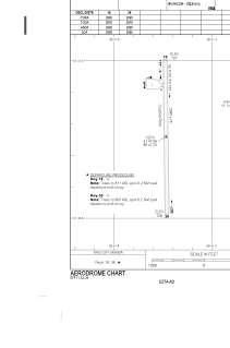
ADC chart of CZTA
 Satellite view of CZTA
Satellite view of CZTA
Sorry, we have no imagery here.
Sorry, we have no imagery here.
Sorry, we have no imagery here.
Sorry, we have no imagery here.
Sorry, we have no imagery here.
Sorry, we have no imagery here.


CZTA - Bloodvein River
Located in , Canada
ICAO - CZTA, IATA - YDV
Data provided by AirmateGeneral information
Coordinates: N51°47'4" W96°41'32"
Elevation is 729 feet MSL.
Magnetic variation is 2.5631° East View others Airports in Manitoba
Operational data
Special qualification required
Current time UTC:
Current local time:
Weather at : CYBV - Berens River ( 68 km )
METAR: CYBV 102018Z 28005KT 15SM OVC020 03/01 A3020 RMK SC8 SLP241
Communications frequencies: [VIEW]
Runways:
| RWY identifier | QFU | Length (ft) | Width (ft) | Surface | LDA (ft) |
| 18 | 179° | 2995 | 75 | GRAVE | 2995 |
| 36 | 359° | 2995 | 75 | GRAVE | 2995 |
Airport contact information
Address: Canada
Satellite view of CZTA
Sorry, we have no imagery here.
Sorry, we have no imagery here.
Sorry, we have no imagery here.
Sorry, we have no imagery here.
Sorry, we have no imagery here.
Sorry, we have no imagery here.