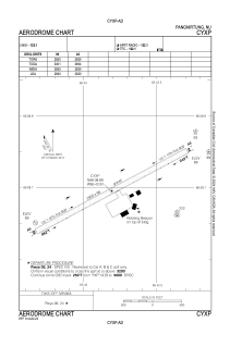
ADC chart of CYXP
 Satellite view of CYXP
Satellite view of CYXP
Sorry, we have no imagery here.
Sorry, we have no imagery here.
Sorry, we have no imagery here.
Sorry, we have no imagery here.
Sorry, we have no imagery here.
Sorry, we have no imagery here.


CYXP - Pangnirtung
Located in Pangnirtung, Canada
ICAO - CYXP, IATA - YXP
Data provided by AirmateGeneral information
Coordinates: N66°8'42" W65°42'49"
Elevation is 79 feet MSL.
Magnetic variation is -28.5953° East View others Airports in Nunavut
Operational data
Special qualification required
Current time UTC:
Current local time:
Weather
METAR: CYXP 022100Z 24002KT 15SM FEW020 M21/M24 A3015 RMK SC1 SC TR SLP217
TAF: TAF CYXP 021840Z 0219/0222 00000KT P6SM FEW020 FEW250 RMK NXT FCST BY 031300Z
Communications frequencies: [VIEW]
Runways:
| RWY identifier | QFU | Length (ft) | Width (ft) | Surface | LDA (ft) |
| 06 | 62° | 2920 | 98 | GRAVE | 2920 |
| 24 | 242° | 2920 | 98 | GRAVE | 2920 |
Airport contact information
Address: Pangnirtung Canada
Satellite view of CYXP
Sorry, we have no imagery here.
Sorry, we have no imagery here.
Sorry, we have no imagery here.
Sorry, we have no imagery here.
Sorry, we have no imagery here.
Sorry, we have no imagery here.